By Dan Briscoe
February 17, 2019
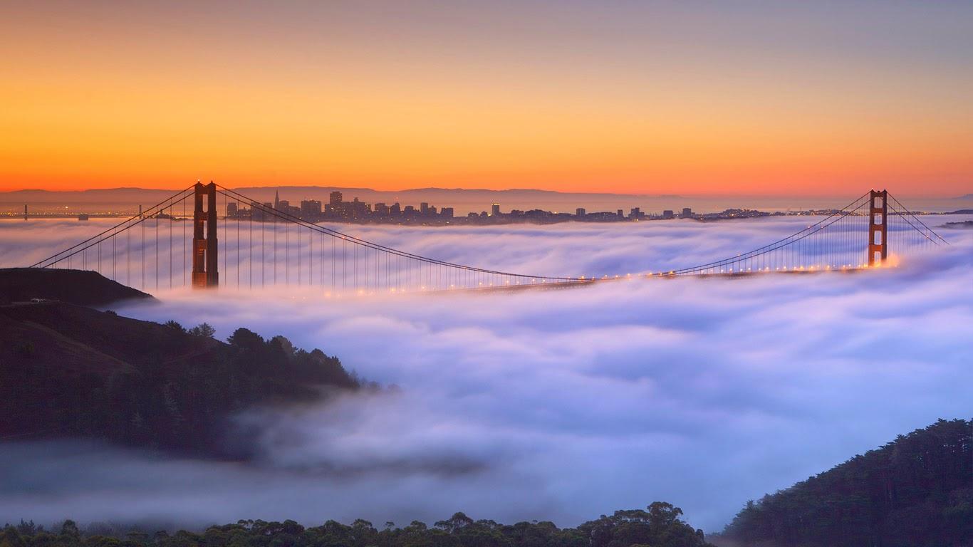
Title Image – A fog-shrouded Golden Gate Bridge in San Francisco, California.
©Della Huff Photography, www.dellahuff.com.
“The coldest winter I ever spent was a summer in San Francisco.” This quote, often erroneously attributed to Mark Twain, is nonetheless affirmation of a weather pattern many visitors to San Francisco have experienced firsthand.
The uneven heating of the Earth’s surface creates our weather. Examining the microclimate of San Francisco and the Golden Gate area helps to illustrate one characteristic of Earth’s global weather engine. San Francisco is unique in that summertime temperatures in the Bay Area can be over 100° F and yet when a cold fog blows in through the Golden Gate the temperature can drop as low as 50° F down on the piers. A few miles southeast, the fog is gone and is the temperature is again over 100° F.
Before we explore San Francisco’s unique weather phenomenon, let’s first talk about air. By volume, dry air contains 78.09% nitrogen, 20.95% oxygen, 0.93% argon, 0.04% carbon dioxide, and small amounts of other gases. Air is a gas and gases can compress or expand. As air is heated the molecules become more active, moving around and bouncing off each other. As this happens, they need more room to play and they get farther apart or less dense. In contrast to this, when air gets colder the molecules are more compact or dense. (In a future post, we will explore Boyle’s law where we will discuss the relationship of temperature, volume, and pressure of gas.)
Water in a gaseous state – water vapor – is generally invisible except when refracting light. Water vapor, can, however, be felt as humidity. Humidity, generally expressed as “Absolute Humidity” or “Relative Humidity” refers to the amount of moisture – water vapor – in the air. For this discussion, when we talk about humidity, we are referring to Relative Humidity, which is a ratio of how much moisture is in the air compared to how much it can contain at the current temperature. In nature, 0% humidity is nearly impossible. All air has a certain amount of water vapor. As air heats up, there is more space between the molecules, allowing more room for more water vapor. When the air becomes saturated with water vapor (100% humidity), the dew point temperature is reached and clouds or fog will form. Warm the air up and it can hold more moisture and the clouds will go away.
Let’s look at the factors influencing the “San Francisco/Golden Gate Weather Engine”:
Cold Moist Marine Air
Predominant onshore flow from the northwest pushes the dense, cold, moist marine air up against the coastal mountain ranges. This airmass adopts the properties of the cool Pacific Ocean as it travels from the Gulf of Alaska or North China Sea. Being dense and heavy, it doesn’t push up over the coastal mountains to form a high-pressure ridge.
Mountain Ranges
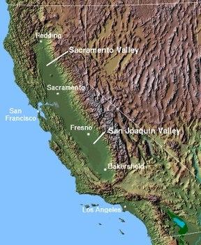
The Coastal Range mountains of California extend hundreds of miles along the coast from northern California to Santa Barbara. The Golden Gate sits at the mouth of San Francisco Bay in a gap between the northern and southern Coast Ranges.
The Coast Ranges to the west and the Sierra Nevada to the east create a huge basin – 450 miles long and 40-60 miles wide – of hot air in the Central Valley. These two mountain ranges act as barriers, keeping the cool marine air out and the warm dryer air in the basin.
The Golden Gate
The narrow gap in the mountains at the mouth of San Francisco Bay is known as the Golden Gate. To the cool dense airmass held back by the coastal mountains, this is like a breach in a dam. The air rushes through this gap to the collide with the lower pressure of the warm air over San Francisco Bay and out to the Central Valley. The Golden Gate acts as a venturi, accelerating the air as it passes through the gap. It then quickly slows down after it has passed through the gap, and dissipates into the large expanse of the Central Valley. If you are unfamiliar with the term venturi, think of the shape of an hour glass. When a fluid or gas moves through the narrow passageway, it accelerates but the static pressure drops. Then as the opening gets bigger again the static pressure increases and the velocity drops. A similar process occurs at the Golden Gate: as the air decompresses going through the Golden Gate, it mixes with the warm air over San Francisco Bay. This warm air has a much higher capacity for containing water vapor. This decompression cools the mixed air and drops it to its dewpoint temperature, thus forming a dense fog bank. In the short distance between the Golden Gate Bridge and the Bay Bridge, the air warms up again and can hold all the moisture in the mixed air without being saturated. The fog disappears.
The California Central Valley
Most of the Central Valley is rich in agriculture. The dark soils of the plowed fields have a very low heat capacity. This means that the soil will heat up quickly with the energy from the sun. Materials with a low heat capacity will also cool quickly as the source of heat is removed. Water, on the other hand, has the highest volumetric heat capacity of all commonly used materials. Therefore, an airmass over water is not heated as much from the ground radiation as it is over the dark soils of the Central Valley in the summer.
The southern end of the Central Valley is classified as desert grasslands. The San Juaquin Valley between Fresno and Bakersfield, which often sets record high temperatures, generates very powerful thermals that act like a vacuum cleaner sucking air from the Central Valley and lifting it far up into the atmosphere. This creates a surface low in the Central Valley and intensifies the flow of dense cold air through the Golden Gate.
Sneak Preview: Global Movement of Air and Weather
In a future post, we will examine Global air movement and weather patterns. Globally, air is moved in much the same way as described above. The sun heats up the earth along the equator and tropics, and the air expands and becomes lighter, creating a low-pressure area. This warm air rises high up into the atmosphere, and – while aloft – pushes out toward the cooler regions of the Earth. As it becomes cooler, it becomes heavier, and settles down to the Earth’s surface, creating higher pressure. This is a circulation of air on a global scale, but there is a lot more to it. We will discuss this in a future post.. Stay tuned!
Satellite Image of San Francisco Bay, https://serc.carleton.edu/vignettes/collection/42858.html,
USGS public domain
Title Image – A fog-shrouded Golden Gate Bridge in San Francisco, California (© Della Huff/Alamy) http://1photo1day.com/a-fog-shrouded-golden-gate-bridge-in-san-francisco-california-della-huffalamy/
Reference links: